Last fall, I was occupied with coursework rather than research. But, since completing all the classes I need for my MSc last December, I dove head-first into research and data processing. I am giving two presentations on my results so far this March: one at Geoconvention in Calgary, and one at SAGEEP in Denver. For anyone curious about my story, this post is an annotated version of my Geoconvention presentation that will let you follow along.
This is a work in progress, so your comments, questions, critiques, and suggestions are all welcome and encouraged.

- Mountain sources account for 2/3 of all surface water flow in the Calgary area. Groundwater storage helps regulate that flow, but our understanding of these groundwater processes is based on only one case study.
- We use geophysics (resistivity and seismic methods) to investigate the subsurface at a new site in the Kananaskis Valley.
- We see some processes that we recognize from earlier studies: there is a thin layer of water flowing on top of bedrock, and there are large buried depressions that store water and slowly release it to surface streams.
- We observe processes that were previously undocumented in Canadian Rocky Mountain headwaters: buried channels, and perched water tables in talus slopes.
- This field site contrasts with our previous case study. These results will help us with forecasting water availability by hinting at which groundwater processes are ubiquitous and which ones appear in only some locations.
1 Introduction
 Alpine watersheds are important sources and stores of fresh water. Essentially, they are the water towers of the world. Globally, mountain regions provide 40-60% of all global surface water runoff (Bandyopadhyay et al, 1997). In the Saskatchewan River Basin, which covers large portions of the Canadian prairies (including the Bow and Elbow Rivers that pass through the city of Calgary), mountain areas on average provide two thirds of total surface water (Viviroli and Weingartner 2004). River levels in this areas are dominated by the timing and volume of snowmelt in alpine zones, meaning that low-lying regions like the prairies are especially vulnerable to climate change (Barnett et al, 2005). Climate modelling in the South Saskatchewan River Basin forecasts earlier spring melts, lower peak river flows in the summertime, and shorter winters (Tanzeeba and Gan, 2012). With such changes imminent, understanding the dynamics of alpine hydrology very important for forecasting the effects on regional water availability, both for the sake of alpine ecosystems and for populated areas downstream.
Mountain photo credit to Flickr user Malcolm (link)
1.1 Groundwater in Alpine Areas
Though the sediments overlying bedrock in high-elevation watersheds may be thin and often coarse-grained, recent work in the Canadian Rocky Mountains has shown that they have substantial groundwater storage potential. Watershed-level studies such as Hood and Hayashi (2015) showed that up to 60-100 mm of water is stored in the subsurface, which represents 10 to 20% of all snowfall in the catchment. This stored groundwater can sustain streamflow throughout the fall and winter. Hence, groundwater cannot be ignored in regional groundwater models.
Several studies have shown how groundwater is directed and stored in the subsurface at a sub-watershed scale. Langston et al. (2011) and Muir et al. (2011) showed that water tends to flow in a thin saturated layer over bedrock in coarse sediments like moraine and talus material. Bedrock depression have also been found to store water and help regulate water table and streamflow levels (McClymont et al., 2010, 2012). Furthermore, frozen ground, ground ice, and relict glaciers acts as an impermeable boundary and tends to direct water into ice-free areas (Langston et al., 2011).
However, while these advances are important in understand mountain groundwater, all of these studies have focused on a single location: the Lake O’Hara watershed in the Main Ranges of the Rocky Mountains. Accurate regional forecasts will depend require a broader understanding of such alpine processes, thus further cases studies are needed to assess which processes are novel, and which are common throughout the Rocky Mountain area.

1.2 Geophysics in Alpine Terrain
Alpine environments pose two difficult challenges for hydrogeology studies. First, most study sites are located in protected lands (e.g. national parks, conservation zones). Second, many sites are difficult to access due to steep terrain and lack of nearby roads. Therefore, drilling wells and installing piezometers is not possible, and many traditional hydrological tools are not available to help characterize the subsurface.
Instead, these studies often rely on geophysical investigations. These non-invasive methods allow us to identify hydrologically significant structures in the subsurface and fill the data gap that a lack of well data imposes on us. Because geophysical data sets are only indirect methods, however, we need to rely on multiple types of survey for our investigations. The most important two that are used are: electrical resistivity tomography (ERT) and seismic refraction.
In a nutshell, here is a description of either method:
- ERT involves passing a direct electrical current through the ground and measuring the potential difference (voltages) across different pairs of electrodes. These measurements together allow us to measure the resistivity of ground materials. An in depth introduction is available here: <link>
- Seismic refraction involves introducing seismic vibration into the ground (in our case, a sledge hammer striking a plate on the ground) and then measuring the time is takes for the wave to travel to receivers along the survey line. Usually, deeper layers tend to transmit seismic waves more quickly. Waves that travel through slower, shallow layers tend to arrive first at nearby receivers, but waves that travel through both slow shallow layers and deep faster layers tend to arrive first at more distant receivers. Noting where the deeper waves overtake the shallower waves lets us model the depth to important geological boundaries. A more detailed primer about this method is available here: <link>
1.3 Petrophysics of Alpine Geology
We use multiple geophysical methods to help reduce ambiguity of our interpretation. This is partly because some materials are not distinguishable using only a single method. Moreover, geophysical measurements do not correspond directly to hydrological properties because there are many different parameters that affect either measurement.
In terms of seismic velocity, the two most important parameters that affect velocity are stress and packing. Generally, as you go deeper, sediments are compressed by a greater weight of material above them, hence they become stiffer. Similarly, loose rubble with many air gaps does not transmit waves as fast as rubble that is more tightly packed, and solid rock transmits waves even faster.
In our studies, the electrical resistivity of materials generally depends on three main parameters: amount of water, the amount of fine-grained materials, and the porosity of the material. Generally, material that is wet conducts electricity more easily than stuff that is dry. Material with fine clay particles generally conducts more easily than material with gravel. Lastly, deposits that have many air pockets and little grain-to-grain contact surface area conducts less easily that deposits where the air gaps are filled with other material.
On the PowerPoint slide, you see some categories of material labelled according to what values you typically see. Note that there is significant variability within any particular category, hence why many such regions are rather large

2 Site Description
2.1 Fortress Mountain
Fortress mountain, our new field study site, is located in the Kananaskis Valley in the Front Ranges of the Southern Canadian Rockies. The area contrasts from the previous study site (Lake O’Hara) in several important ways:
- Surficial geology: The area has no active glaciers, so many of the landforms are much older. Moreover, we have a wide variety of different deposits in a very small area, so we can get a good understanding of how many different deposits interact with groundwater without having to study a big area
- Bedrock: Because we are the Front Rangers rather than the Main Ranges of the Rocky Mountains, we tend to have younger, less competent sedimentary bedrock as opposed to strong, resistant, metamorphic bedrock
- Groundwater dominated: There are many springs and streams in unusual locations that make it obvious that this new site is groundwater dominated
- Headwater basin for the Bow River: This basin is one of the headwater basins feeding into the Bow River which passes through Calgary, the province of Alberta’s most populous city.
- Movie Stars: Scenes of both “The Revenant” and “Inception” were filmed here, and it is a perk to work in a location beautiful enough to warrant being on the silver screen.

2.2 3D Tour of Fortress Mountain
To get a sense of what the
study area looks like, take a look at this 3D rendering of the mountain. This
location used to be a ski hill, and you can see old ski runs and a ski lodge
building in on the east end of the area. The video starts from a bird`s-eye
view, and ends in an oblique view facing southwest.
2.3 Surficial Geology
The PowerPoint slide shows an oblique photo with important surficial units coloured in:
- Orange and yellow: talus slopes and cones.
- These are large piles of rock fallen from the large cliffs just to the south (see photo)
- Blue: moraines
- These are linear piles of rock formed by glaciers. There is a complex array of them surrounding the lake on site. The crests of these moraines are traced out in an elevation map (see slide)
- Green: meadow
- This is a flat, low-elevation, grassy area located at the bottom of the talus slopes and at the south side of the lake. The meadow is made up of mostly wet, fine-grained material.


2.4 Bedrock Geology
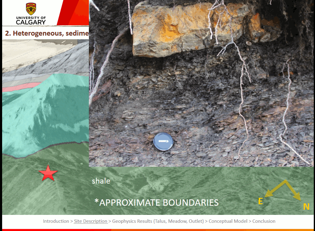
At this location, we have older Carboniferous and Devonian rocks thrust on top of Jurassic rocks.
- The Jurassic rocks in the bottom of the valley are made up mainly of very weak shale that can be ripped apart with one’s bare hands (see photo).
- The cliff walls, which are made up of the older rocks and which are over 300 m tall, are mostly made of carbonate rocks like limestone from the Palliser Formation. Most of the rubble in the talus and the moraines seem to be composed of these hard rocks from the cliffs.
- There are some softer, weaker rocks (e.g. shale) at high elevations above the main cliff walls.
2.5 Surficial Hydrology
The slide shows a few interesting features: blue dots indicate spring locations, while blue lines show longer, continuous streams. There are a few mysteries of groundwater we cannot explain from surface observations alone:
1. The source of the outlet stream
There is a relatively large stream downslope of the lake that runs year-round. Yet, there is no visible connection between the lake and this stream. What is the pathway that connects the two?
2. The seasonality and size of lake inlets
There are two ways that water enters the lake: a surface stream that comes from the meadow, and several groundwater springs that seems out of the south banks of the lake. However, the lake and surface inlet only have water in them up until late summer, in contrast to the outlet stream. Moreover, the discharge from the surface stream and the small springs on the shore of the lake are not large enough together to account for the flow at the outlet.
Where is the rest of the water coming from that maintains the year-round flow of the outlet?
3. Springs on the talus surface
While we have seen springs at the toe of the talus before, this is one of the first times we’ve spotted springs higher up on the talus slope. What is causing these springs to come to surface at these locations?

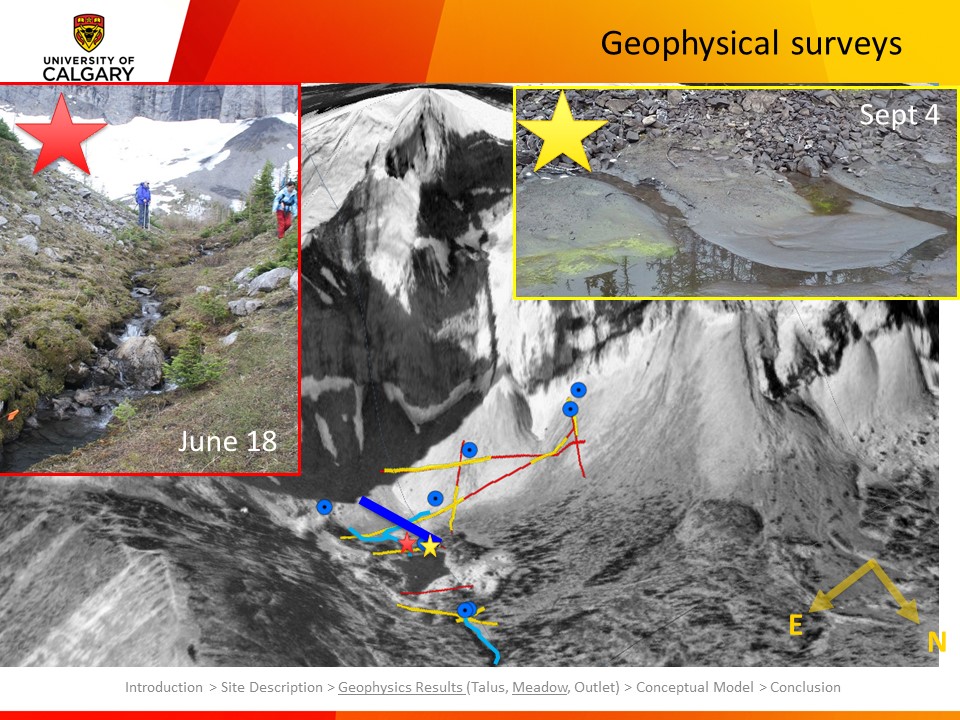
3 Geophysics Results
Over the course of three weeks in July 2015, we collected 9 ERT survey lines, and multiple overlapping seismic refraction lines to help address those unanswered questions about the hydrogeology of this site.
 |
| Red: Locations of resistivity (ERT) surveys Yellow: Locations of seismic refraction surveys |
3.1 Talus Slope
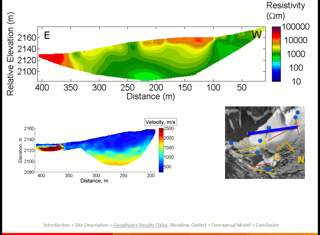
3.1.1 Line 1
On this line, we have a clear signal from the seismic data: There is bedrock not too far below surface that is buried under loose, unconsolidated rubble. The resistivity data indicates a saturated zone near the start of the line at an elevation of 2193 m. This corresponds to a spring at the same elevation just a few metres away from this line.
Hence, it seems that we have flow of water in a saturated zone sitting on top of bedrock. This is in agreement with was we saw in earlier studies at Lake O’Hara.

3.1.2 Line 2
This line contrasts considerably with the first survey line on the talus. Like that first line, there is a spring at surface on the talus near the geophysics line. In fact, this spring has enough flow to sustain a community of willow trees. However, in this case, bedrock is over 30 m deep. If it is not bedrock, there must be a different impermeable layer preventing the water from infiltrating down further into the slope.
An important note about the ERT section: The electrode spacing used was 8 m as opposed to 4 m in the previous line. Given that the resolution of the image is lower and that each pixel represents the average of a larger volume of earth, the saturated zones around the spring appear more resistive.
Lastly, at the end of the line, we see an extremely resistive, high-velocity anomaly. It is difficult to distinguish between bedrock an ice. We installed temperature sensors last fall in order to help us make that distinction. These will be retrieved in June once the site is accessible again.

3.2 Meadow
This line crosses the meadow on a roughly north-south
bearing, and comes close to the south edge of the lake. The photos highlight
two different inlets to the lake: the surface stream running through the meadow
(red star) and the springs on the lakeshore where groundwater is seeping into
the lake (yellow star).
On the resistivity image, we see very clearly a low
resistivity area that corresponds to the wet, fine-grained sediments that we
see at surface. In the seismic section, we see a high-velocity layer at depth.
I have created a composite image that overlays the two data types together, and
the legend in the lower left shows which colours correspond to which
properties:
·
Magenta: loose, high-resistivity
deposits (moraine, talus)
·
Blue and black: low resistivity, low
velocity deposits (fine-grained, wet sediments)
·
Green and yellow: high resistivity,
high-velocity (bedrock, till)
We see at depth a transition to high velocities and high
resistivities (black dashed line). Zooming in on the composite image, and
comparing to elevation of important hydrological features, we see that the upper
elevation of this yellow and green layer corresponds to the elevation of where
groundwater (GW) discharges into the lake. This suggests to us that this lower
layer may be controlling the elevation of these spring, and may be acting as a
dam for the reservoir under the meadow. Moreover, the layer dips well below the
elevation of the lake and down to roughly the elevation of the springs at the
outlet


3.3 Outlet Spring
In these photos, you see the
outlet spring and stream at two different times of year. In either, you can see
the moraine rising in the background, and the water emerging from a pile of
cobbles in the foreground. The staff gauge in either is immediately downstream
of this spring, and shows that flow is fairly consistent from mid-summer to
mid-autumn.
 The resistivity data shows a
clear distinction between dry moraine material (on the east side of the spring)
and wet, fine-grained sediments in a forest clearing on the west side. There
are strange, low-resistivity bullseyes near the spring which we thought were
data artifacts at first. However, looking at the seismic model, we notice a
clear boundary in the vicinity of the spring. Superimposing this on the
resistivity image, we see that these low-resistivity bullseyes are nestled
right in these dips in bedrock. We are
interpreting these as buried channels incised into the bedrock.
The resistivity data shows a
clear distinction between dry moraine material (on the east side of the spring)
and wet, fine-grained sediments in a forest clearing on the west side. There
are strange, low-resistivity bullseyes near the spring which we thought were
data artifacts at first. However, looking at the seismic model, we notice a
clear boundary in the vicinity of the spring. Superimposing this on the
resistivity image, we see that these low-resistivity bullseyes are nestled
right in these dips in bedrock. We are
interpreting these as buried channels incised into the bedrock. 
4 Wrap-up
4.1 Preliminary Conceptual Models
4.1.1 Talus
We saw in the first geophysics lines on the talus that bedrock
acts as impermeable boundary and water flows over top a it. This similar to observations
in previous field sites in the Rocky Mountains. Unlike previous sites, in some
parts of the talus slope, the water table is perched up high above the bedrock.
This suggests that there is something about the structure of these slopes that
contrasts with other areas.
We notice, just as Pierson (1982) observed, that the grain
size of the rubble in these talus slopes varies laterally. In locations where
springs are perched well above the bedrock, the grains in the slope are of a
large variety of sizes. (See the picture below). We speculate that the weaker,
incompetent Carboniferous shales on at the top of these cliffs are weathered
into smaller grains than the stronger limestones, leading to the well-graded
deposits observed. This distribution of sizes leads to a denser packing, and hence
to a lower hydraulic conductivity.

These observations have implications for how we predict
streamflow in large basins as such. Talus slopes with lower-hydraulic
conductivity may be able to retain water for longer periods, but will have
lower infiltration rates. Precipitation forecasts tend to be less certain than
temperature change forecasts in the area, but if more extreme fluctuations in
precipitation occur, a higher proportion of water may runoff over land as
opposed to run infiltrate underground. This variation in hydraulic conductivity
of talus slopes may need to be considered when taking inventory of talus slopes
in alpine watershed and selecting appropriate modelling parameters. Heterogeneous
bedrock composition of valley walls may affect the hydrogeological properties of
these, and more research is warranted on whether there is a predictable
relationship between rock types and slope properties.
4.1.2 Meadow, Lake, and Outlet Spring
Taking elevation of the impermeable layer we see at depth and the surface elevations, we have put together this conceptual model:
- During summer and spring, following snowmelt, the water table intersects the surface and the lake is full
- As snowmelt inputs drop off and water table levels drop below the lakebed elevation, the lake appears to dry up. Flow of the outlet spring is maintained because there is a large depression in the bedrock underneath the meadow. This depression helps ensure that gradients do not drop too much, helping keep outlet streamflow steady.

A few notes about the image and the model:
- Vertical exaggeration in the figure is 2 to 1, so the water table drop is not as large as it may appear
- There are likely three-dimensional effects to consider. The channels at the buried channels suggest that water is focused into that outlet spring, which may further help maintain water levels in the stream.
In essence, we have found another case where a large depression in an impermeable layer is storing a large amount of water and helping regulate streamflow. This is also the first instance, within our research team, that we have geophysical evidence of buried channels in an alpine setting.
4.2 Conclusion
Some take-home points
- We documented two processes that we observed before at other sites: groundwater flow at the bedrock interface, and the presence of a bedrock reservoir below a meadow that helps regulate streamflow. These results may suggest that such processes are common in alpine ones in the Rocky Mountains
- We observed some new processes.
- There can be shallow flow in talus slopes, and we speculate that it is caused by a tighter packing of grains due to heterogeneous bedrock composition in the valley headwall
- We observed buried channels near a large spring, the first time we have seen such structures in an alpine setting.
In the coming months, we will be
focusing on refining our interpretations and our conceptual model, and we have
more data that we can use (mainly ground penetrating radar data). We will
likely do some more geophysical field work this summer to help us solidify test our early models.

4.3 Acknowldgements
This work, as previous entries on this blog suggest, were
the work of a large team of volunteers toiling away for nearly three weeks
straight last July. Many thanks to them!
 We collaborated with researchers from the University of
Saskatchewan who have studied the ecology, surface hydrology, and meteorology of Fortress Mountain.
Thank you to Dr. John Pomeroy, Dr. Cherie Westbrook, May Guan, and Hongye Wu
for all their insights and advice.
We collaborated with researchers from the University of
Saskatchewan who have studied the ecology, surface hydrology, and meteorology of Fortress Mountain.
Thank you to Dr. John Pomeroy, Dr. Cherie Westbrook, May Guan, and Hongye Wu
for all their insights and advice.
We thank the folks at Fortress Mountain for giving us access
to this unique and fascinating site. Best of luck with your efforts to reopen
the ski hill!
And finally, this research was funded through a NSCERC
Discovery Grant.
References
Bandyopadhyay, J.,
Kraemr, D., Kattelmann, R., & Kundzewicz, Z. (1997). Highland watrs: a resource of
global significance. In B. Messerli & J. Ives (Eds.), Mountains of the
World: A Global Priority (pp. 131–151). New York: Parthenon.
Barnett, T. P., Adam, J. C., & Lettenmaier, D. P. (2005).
Potential impacts of a warming climate on water availability in snow-dominated
regions. Nature, 438(7066), 303–309.
http://doi.org/10.1038/nature04141
Hood, J. L., & Hayashi, M. (2015). Characterization of
snowmelt flux and groundwater storage in an alpine headwater basin. Journal
of Hydrology, 521, 482–497.
http://doi.org/10.1016/j.jhydrol.2014.12.041
Langston, G., Bentley, L. R., Hayashi, M., McClymont, A., &
Pidlisecky, A. (2011). Internal structure and hydrological functions of an
alpine proglacial moraine. Hydrological Processes, 2982(May),
n/a–n/a. http://doi.org/10.1002/hyp.8144
McClymont, a. F., Hayashi, M., Bentley, L. R., & Liard, J.
(2012). Locating and characterising groundwater storage areas within an alpine
watershed using time-lapse gravity, GPR and seismic refraction methods. Hydrological
Processes, 26(12), 1792–1804. http://doi.org/10.1002/hyp.9316
McClymont, A. F., Hayashi, M., Bentley, L. R., Muir, D., &
Ernst, E. (2010). Groundwater flow and storage within an alpine meadow-talus
complex. Hydrology and Earth System Sciences, 14(6), 859–872.
http://doi.org/10.5194/hess-14-859-2010
Muir, D. L., Hayashi,
M., & Mcclymont, A. F. (2011). Hydrological storage and transmission characteristics of an alpine
talus. Hydrological Processes, 25(March), 2954–2966.
http://doi.org/10.1002/hyp.8060
Pierson, T. C. (1982). Classification and hydrological
characteristics of scree slope deposits in the Northern Craigieburn Range, New
Zealand. Journal of Hydrology (New Zealand). Retrieved from
http://hydrologynz.co.nz/downloads/20080523-044709-JoHNZ_1982_v21_1_Pierson.pdf
Tanzeeba, S., &
Gan, T. Y. (2012). Potential
impact of climate change on the water availability of South Saskatchewan River
Basin. Climatic Change, 112(2), 355–386.
http://doi.org/10.1007/s10584-011-0221-7
Viviroli, D., & Weingartner, R. (2004). The hydrological
significance of mountains: from regional to global scale. Hydrology and
Earth System Sciences, 8(6), 1017–1030.
http://doi.org/10.5194/hess-8-1017-2004
No comments:
Post a Comment