The avalanche danger and treacherous roads keep me away from my field site all winter, but now that the snow is finally done and there are no more looming cornices way up high on those cliffs, it's time for a second field season.
I am planning 5 additional days of geophysical data collection later this July, but I've been busy in the meantime collecting temperature and electrical conductivity measurements of water, setting up time-lapse cameras, installing piezometers and stilling wells, and taking samples. Here's a selection of nice photos showing what I've done so far.
 |
| Wading through Bonsai Lake on a warm, sunny day in late June. |
June 14, 2016
This was my first day back on site since October 22. After processing geophysical data all winter, it great to come back to site armed with all that new knowledge and keener eyes. I was joined by my supervisor Dr. Masaki Hayashi and a new colleague joining our lab, Anna Pakinasova. It was a chilly day, and we got snowed during a few brief periods, but a pleasant day nonetheless.
 |
| Installing a time-lapse camera on the eastern ridge of the watershed, with Anna's help |
 |
| One of the temperature sensors (B05) that I left behind here back in late October. |
 |
| Locating that spring is going to be tricky if it's buried way below the snow |
 |
| Here's a shot showing how the composition of the snow on the talus varies. |
 |
| A view looking down on the meadow from the SW |
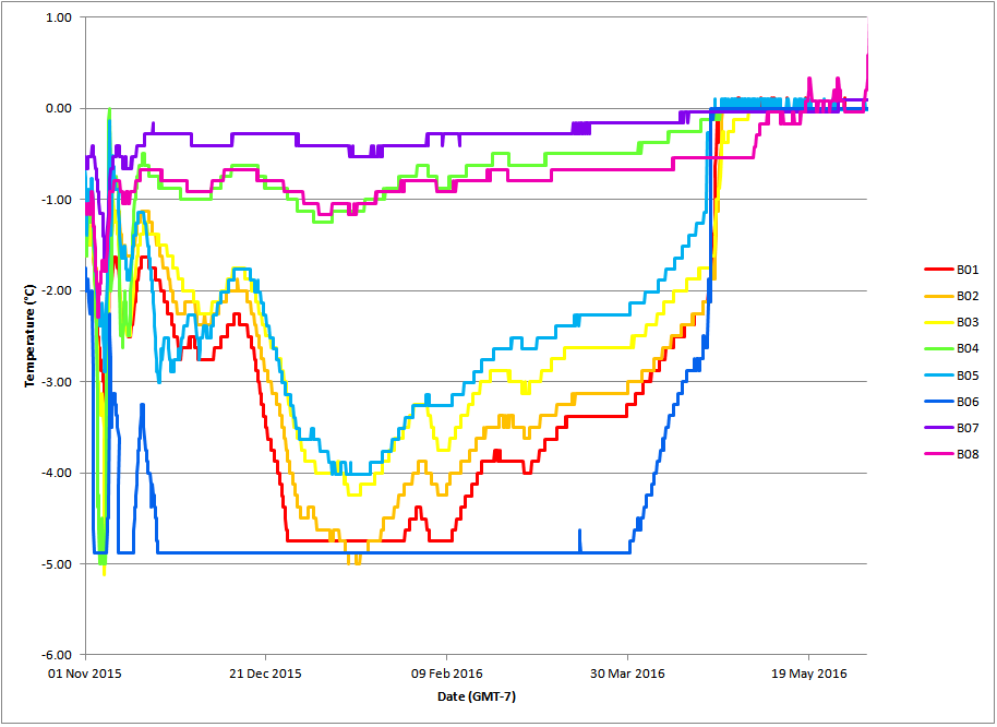
One of the main goals was retrieving the temperature sensors that I
left behind last October. One of the most significant anomalies I saw in
the geophysics data was a high-resistivity, high-(seismic)-velocity
feature at a very shallow depth on the talus. Both intact bedrock and
ice have have those electrical and seismic properties, but I could rule out ice if that spot is
too warm in the winter to sustain ice below ground. Hence, I placed
three temperature sensors (B01, B02, and B03) on top of this anomaly.
As
it turns out, the temperature of the ground below snowpack does remain
below -3°C for most of the winter, which means that I cannot rule out underground ice (a.k.a. permafrost). This spot is roughly 2130 metres above sea level, which is rather low elevation for finding ice in this area of the Rocky Mountains.
 |
| A map showing the locations of the temperature sensors |
 |
| Temperature data retrieved. Note that the sensors cannot measure temperatures below -5°C. Notice how there is a long period where temperatures are a constant 0°C during spring snowmelt. |
|
June 24, 2016
Today, I was joined by Luke Kary and Brandon Hill. We mainly did some soil auguring and then some installation of piezometers. I'm trying to compare water levels over time in the meadow versus those in the lake. I suspect that they fluctuate much less in the meadow because it's a finer-grained materials, so that allows it to act as an important storage location for water in later parts of the season.
 |
| Luke auguring our first hole in the meadow |
 |
| One of our complete piezometers |
 |
| We witnessed a major rockfall while on site. Unfortunately, I didn't have my camera during the fall, so I only got a photo of the aftermath |
 |
| Noting some interesting changes in colour in our soil column. |
 |
| Brandon and Luke sealing off our third pieozometer. |
June 28, 2016
Our main goals today were to finish installing water level loggers in our piezometers, and to install a stilling well in Bonsai Lake. It was a gorgeous day to be outside, and made wading through cold water all the more pleasant.
 |
| A nice view of one of the talus cones. You can see a few channels carved out by meltwater quite well in this photo. There are a few springs that disappear and reappear as you go downslope. |
 |
| Laura Beamish and Luke Kary with me |
 |
| A nice view looking south from the shore of Bonsai Lake |
 |
| Getting some help readying the equipment for our stilling well. |
 |
| Me, setting up the support for the stilling well in Bonsai Lake |
 |
| Luke is doing some auguring trying to see if we can hit bedrock. |
 |
| Still trying to reach bedrock, but no luck. |
July 7, 2016
Our group is starting to make use of radon gas measurements to assess how long water has been underground (that is, the average residence time). We are able to do this because all rocks contain small amounts of radioactive atoms that decay, producing radon gas. Underground, these gasses move through cracks in the rock, dissolving and slowly accumulating in the groundwater. Hence, the longer that water is underground, the more radon it will contain.
However, each rock formation releases radon gas at a different rate. Hence, we need to mix rocks and water in the lab and measure the changes in radon gas over time there before we can interpret what our field measurements mean. Today's mission was to collect some rock samples of two of the major
bedrock units present at this site: the Palliser Formation (a carbonate
rock of Carbiniferous age) and the Fernie Formation (a weak, black shale
of Jurrasic age).
 |
| Picking up some samples of the Palliser Formation |
 |
| Laura Beamish helping me out for the day |
 |
| Digging to get to an outcrop of the Fernie Formation |
 |
| We're at the top of the old chairlifts at Fortress Mountain. It's an eerie site. |
 |
| Marmots may look cute, but they have a bad habit on chewing on geophysics cables. |
 |
| Checking up on the stilling well at Bonsai Lake. The water level went down about 10 cm since June 28. |


No comments:
Post a Comment